data exploration in the Cream City
A Rustbelt Makeover
Here’s some of your rough government data, Milwaukee. With a new cut and polish, you really shine.
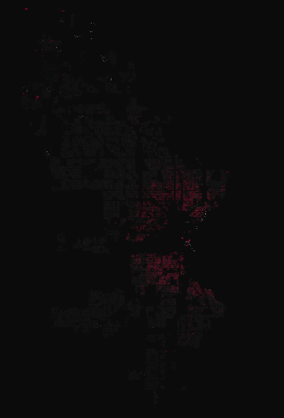
This interactive map is built from a simple data series: the ages of 139,931 residential buildings in Milwaukee, Wisconsin. The building data, maintained by the City of Milwaukee as part of a larger property database, has been hidden in plain sight for years.
Using only the age of a building plus the shape of the property that it sits upon, this map invites you to explore a city in a new way. Even a casual user can find quick insight in the data – perhaps noting new infill development in Milwaukee’s core (an indicator of urban renewal?).
Or, seeing how past housing booms still shape the nature and distribution of the City’s existing housing stock.
Explore the patterns on your own block – click here for the complete, zoomable map. Learn more about the map’s data and inspiration here.
32 notes
architecturalinfection reblogged this from milwaukeestat
quoideneufliz reblogged this from milwaukier-than-thou
respectedwanderer-blog liked this
leopard-sky liked this
ocratitude reblogged this from hellodahlie
stoopkidsmke liked this
 philosophyandpolitics reblogged this from hellodahlie
 hellodahlie reblogged this from milwaukeestat
xburgerkingfootlettucex liked this
brainmoult liked this
karstrx99 liked this
danhoan liked this
arenaoftheunwell liked this
travsi reblogged this from milwaukier-than-thou
shotfromguns liked this
nzukauskas liked this
16thwonder liked this
 trollcave liked this
 milwaukier-than-thou reblogged this from milwaukeestat
quietstorm1234 liked this
whoneedscats liked this
milwaukeestat posted this